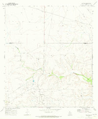
1970 Map of Texon SE
USGS Topo · Published 1973About this map
The World Powell Field dominates this West Texas landscape, showing a complex industrial network of Pipelines and Oil Wells established by 1970. The terrain is defined by the winding course of Schneemann Draw, which cuts through the topography along the boundary of Reagan Co and Crockett Co. Evidence of mid-century infrastructure is visible in the scattered Gravel Pits, a Substa, and a Pumping Sta that support the energy operations in this portion of the Permian Basin.
Find a feature on this map
13 named features on this map. Tap any name to fly to it.
Don’t see what you’re looking for? This feature index may not catch every label — zoom into the map to look around manually.
Map Details
Editions of this 1970 Texon SE Map
This is the sole edition of this map. No revisions or reprints were ever made.
Other maps of this area

1920 · Big Lake
USGS Topo · 1:62,500

1922 · Big Lake
USGS Topo · 1:62,500

1928 · Rankin
USGS Topo · 1:125,000

1929 · Sheffield
USGS Topo · 1:125,000

1954 · Sonora
USGS Topo · 1:250,000

1954 · San Angelo
USGS Topo · 1:250,000

1958 · Sonora
USGS Topo · 1:250,000

1958 · San Angelo
USGS Topo · 1:250,000

1965 · San Angelo
USGS Topo · 1:250,000

1967 · Owens Creek NE
USGS Topo · 1:24,000