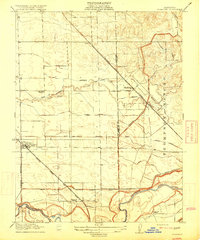
1915 Map of Thalheim
USGS Topo · Published 1915About this map
Escalon stands as a primary railroad hub in this San Joaquin Valley landscape, situated at the junction of the Atchison Topeka and Santa Fe and the Tidewater Southern lines. To the northeast, the settlement of Thalheim serves as a secondary nexus where the Southern Pacific tracks bisect a complex network of irrigation infrastructure. This 1913 survey documents the extensive transformation of the arid valley floor into a highly managed agricultural district, defined by the South San Joaquin Irrigation District Canal and a dense system of laterals including the Hirshfeld Lateral and Thalheim Lateral.
Find a feature on this map
25 named features on this map. Tap any name to fly to it.
Don’t see what you’re looking for? This feature index may not catch every label — zoom into the map to look around manually.
Map Details
Editions of this 1915 Thalheim Map
2 editions found
Other maps of this area

1914 · Avena
USGS Topo · 1:31,680

1915 · Oakdale
USGS Topo · 1:31,680

1915 · Trigo
USGS Topo · 1:31,680

1915 · Peters
USGS Topo · 1:31,680

1915 · Salida
USGS Topo · 1:31,680

1915 · Thalheim
USGS Topo · 1:31,680

1916 · Riverbank
USGS Topo · 1:31,680

1916 · Waterford
USGS Topo · 1:31,680

1916 · Bachelor Valley
USGS Topo · 1:31,680

1939 · Modesto East
USGS Topo · 1:62,500