
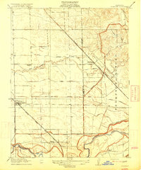
1915 Map of Thalheim
USGS Topo · Published 1915About this map
Agricultural development along the boundary of San Joaquin and Stanislaus counties is the focus of this 1913 survey. The landscape is defined by an intricate network of irrigation infrastructure, including the South San Joaquin Irrigation District Canal and numerous laterals like the Hirshfeld Lateral and Cometa Lateral. The settlement of Thalheim serves as a local hub along the Oakdale Branch of the Southern Pacific railroad, while the growing town of Escalon sits at the junction of the Atchison Topeka and Santa Fe and the Tidewater Southern lines. The southern portion of the map reveals the winding course of the Stanislaus River, which forms a natural border below the historic Thompson Rancho. Small rural centers are evidenced by Lone Tree School, Burwood School, and Huntley, highlighting the distributed nature of the early 20th-century farming community.
Find a feature on this map
29 named features on this map. Tap any name to fly to it.
Don’t see what you’re looking for? This feature index may not catch every label — zoom into the map to look around manually.
Map Details
Editions of this 1915 Thalheim Map
2 editions found
Other maps of this area

1914 · Avena
USGS Topo · 1:31,680

1915 · Oakdale
USGS Topo · 1:31,680

1915 · Trigo
USGS Topo · 1:31,680

1915 · Peters
USGS Topo · 1:31,680

1915 · Salida
USGS Topo · 1:31,680

1916 · Riverbank
USGS Topo · 1:31,680

1916 · Waterford
USGS Topo · 1:31,680

1916 · Bachelor Valley
USGS Topo · 1:31,680

1939 · Modesto East
USGS Topo · 1:62,500
1941 · Modesto West
USGS Topo · 1:62,500