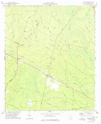
1978 Map of Thalmann
USGS Topo · Published 1978About this map
The low-lying pine barrens and wetlands of Glynn County are captured here at the intersection of the Seaboard Coast Line and Southern railroads. The small settlement of Thalmann serves as a central junction, surrounded by an intricate network of named hammocks and islands that rise slightly above the saturated landscape, such as Pepper Hammock, Big Island, and Gibson Island. This 1970s survey reveals a deeply rooted rural community, indicated by numerous family-named cemeteries and landmarks scattered along historical routes like Post Road. The map documents the complex drainage of the area, where the Little Buffalo Swamp and Buffalo Swamp dominate the topography. Local history is preserved through the locations of the Popwellville settlement and several rural houses of worship, including Hopewell Ch and Trinity Ch, alongside smaller work sites like the Claypit and various flowing wells that punctuate the coastal plain.
Find a feature on this map
56 named features on this map. Tap any name to fly to it.
Don’t see what you’re looking for? This feature index may not catch every label — zoom into the map to look around manually.
Map Details
Editions of this 1978 Thalmann Map
This is the sole edition of this map. No revisions or reprints were ever made.
Other maps of this area

1917 · Nahunta
USGS Topo · 1:62,500

1918 · Hortense
USGS Topo · 1:62,500

1918 · Everett City
USGS Topo · 1:62,500

1918 · Nahunta
USGS Topo · 1:62,500

1918 · Bladen
USGS Topo · 1:62,500

1920 · Everett City
USGS Topo · 1:62,500

1939 · Bladen
USGS Topo · 1:62,500

1944 · Everett City
USGS Topo · 1:62,500

1944 · Hortense
USGS Topo · 1:62,500

1946 · Brunswick
USGS Topo · 1:250,000