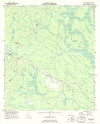
1993 Map of Thalmann
USGS Topo · Published 1995About this map
Thalmann serves as a central point in this low-lying landscape where the coastal plains of Glynn, Wayne, and Brantley Counties meet. The area is defined by an intricate network of wetlands, including Little Buffalo Swamp and Pumpkin Swamp, which weave around elevated landforms known as hammocks. These islands of drier ground, such as Pepper Hammock and Du Bignon Hammock, historically provided habitable spaces and agricultural land amidst the surrounding marsh. The map shows several flowing wells and a scattering of small settlements like Popwellville and Jamaica, suggesting a rural economy tied closely to the water table and local timber or farming resources.
Find a feature on this map
49 named features on this map. Tap any name to fly to it.
Don’t see what you’re looking for? This feature index may not catch every label — zoom into the map to look around manually.
Map Details
Editions of this 1993 Thalmann Map
This is the sole edition of this map. No revisions or reprints were ever made.
Other maps of this area

1917 · Nahunta
USGS Topo · 1:62,500

1918 · Hortense
USGS Topo · 1:62,500

1918 · Everett City
USGS Topo · 1:62,500

1918 · Nahunta
USGS Topo · 1:62,500

1918 · Bladen
USGS Topo · 1:62,500

1920 · Everett City
USGS Topo · 1:62,500

1939 · Bladen
USGS Topo · 1:62,500

1944 · Everett City
USGS Topo · 1:62,500

1944 · Hortense
USGS Topo · 1:62,500

1946 · Brunswick
USGS Topo · 1:250,000