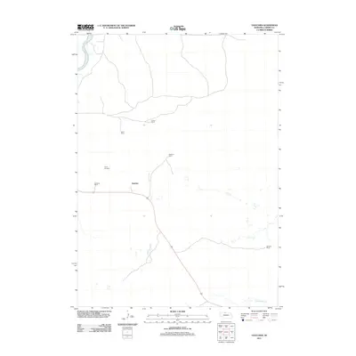
2011 Map of Thatcher
USGS Topo · Published 2011About this map
Thatcher sits at the heart of this Cherry County landscape, a region defined by its ranching heritage and the flowing waters of the Niobrara River in the northwest. The settlement pattern here is characterized by sparse, family-named ranching operations, including Paxson Ranch, Taylor Ranch, and Swanson Ranch, which mark the sprawling reaches of the Nebraska sandhills. Near the center of the sheet, the Taylor Cemetery provides a specific point of interest for genealogists tracing the legacy of early settlers in this quiet corner of the state. To the southeast, Fairfield Creek cuts through the terrain, further illustrating the vital role of water in sustaining these isolated ranching outposts. This 2011 survey documents a modern snapshot of a traditional agricultural landscape, where the footprint of human habitation remains closely tied to the natural drainages and grazing lands.
Find a feature on this map
9 named features on this map. Tap any name to fly to it.
Don’t see what you’re looking for? This feature index may not catch every label — zoom into the map to look around manually.
Map Details
Editions of this 2011 Thatcher Map
This is the sole edition of this map. No revisions or reprints were ever made.
Other maps of this area

1950 · Sparks
USGS Topo · 1:62,500

1950 · Simeon
USGS Topo · 1:62,500

1950 · Arabia
USGS Topo · 1:62,500

1950 · Valentine
USGS Topo · 1:62,500

1957 · Valentine
USGS Topo · 1:250,000

1959 · Valentine
USGS Topo · 1:250,000
1983 · Sparks
USGS Topo · 1:24,000
1983 · Valentine North
USGS Topo · 1:24,000

1983 · Valentine South
USGS Topo · 1:24,000
1983 · Thatcher
USGS Topo · 1:24,000