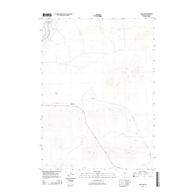
2014 Map of Thatcher
USGS Topo · Published 2014About this map
The settlement of Thatcher occupies a central position in this Cherry County landscape, situated along the path of Us-20 and the notable Cowboy Trl. To the northwest, the terrain gives way to the deep valley of the Niobrara River, where the protected lands of the Niobrara NSR border the water's edge. This 2014 survey documents a region defined by its vast grazing lands and sparse development, typical of the Nebraska Sandhills. Local history is anchored by sites like the Taylor Cem north of the highway, while the southeastern corner is drained by Fairfield Cr. The presence of the Cowboy Trail, a converted rail corridor, highlights the transition from traditional railroad infrastructure to modern recreational use in this rural ranching community.
Find a feature on this map
7 named features on this map. Tap any name to fly to it.
Don’t see what you’re looking for? This feature index may not catch every label — zoom into the map to look around manually.
Map Details
Editions of this 2014 Thatcher Map
This is the sole edition of this map. No revisions or reprints were ever made.
Other maps of this area

1950 · Sparks
USGS Topo · 1:62,500

1950 · Simeon
USGS Topo · 1:62,500

1950 · Arabia
USGS Topo · 1:62,500

1950 · Valentine
USGS Topo · 1:62,500

1957 · Valentine
USGS Topo · 1:250,000

1959 · Valentine
USGS Topo · 1:250,000
1983 · Sparks
USGS Topo · 1:24,000
1983 · Valentine North
USGS Topo · 1:24,000

1983 · Valentine South
USGS Topo · 1:24,000
1983 · Thatcher
USGS Topo · 1:24,000