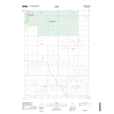
2017 Map of Thatcher
USGS Topo · Published 2017About this map
Fort Niobrara National Wildlife Refuge dominates the northern reaches of this landscape in Cherry County, where the plains give way to the wooded breaks of the Niobrara River. This 2017 survey captures the sparse settlement patterns of the Nebraska Sandhills, anchored by the small community of Thatcher near the center of the sheet. The terrain is defined by a dense network of wetlands and small kettle lakes to the south, contrasting with the riverine environment along the Niobrara National Scenic River in the northwest corner. Genealogists may find interest in the Taylor Cem, situated west of the main road, which serves as a quiet marker of the families who settled this open country. The southern half of the map is particularly water-rich, featuring Fairfield Cr and dozens of unnamed ponds that illustrate the unique hydrology of the Sandhills region.
Find a feature on this map
12 named features on this map. Tap any name to fly to it.
Don’t see what you’re looking for? This feature index may not catch every label — zoom into the map to look around manually.
Map Details
Editions of this 2017 Thatcher Map
This is the sole edition of this map. No revisions or reprints were ever made.
Other maps of this area

1950 · Sparks
USGS Topo · 1:62,500

1950 · Simeon
USGS Topo · 1:62,500

1950 · Arabia
USGS Topo · 1:62,500

1950 · Valentine
USGS Topo · 1:62,500

1957 · Valentine
USGS Topo · 1:250,000

1959 · Valentine
USGS Topo · 1:250,000
1983 · Sparks
USGS Topo · 1:24,000
1983 · Valentine North
USGS Topo · 1:24,000

1983 · Valentine South
USGS Topo · 1:24,000
1983 · Thatcher
USGS Topo · 1:24,000