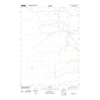
2010 Map of Thatcher Hill
USGS Topo · Published 2010About this map
Bear River winds through this section of Franklin County, carving a path through the valley just east of the prominent Thatcher Hill. The landscape is defined by its sophisticated irrigation network, most notably the Gentile Valley Canal, which skirts the base of the hills to support the agricultural vitality of Gem Valley. This 2010 survey illustrates a rural corridor where water management and topography dictate the layout of local infrastructure and land use.
Find a feature on this map
23 named features on this map. Tap any name to fly to it.
Don’t see what you’re looking for? This feature index may not catch every label — zoom into the map to look around manually.
Map Details
Editions of this 2010 Thatcher Hill Map
This is the sole edition of this map. No revisions or reprints were ever made.
Other maps of this area

1915 · Preston
USGS Topo · 1:96,000

1918 · Preston
USGS Topo · 1:125,000

1948 · Bancroft
USGS Topo · 1:62,500

1948 · Soda Springs
USGS Topo · 1:62,500

1949 · Bancroft
USGS Topo · 1:62,500

1949 · Soda Springs
USGS Topo · 1:62,500

1955 · Preston
USGS Topo · 1:250,000

1958 · Preston
USGS Topo · 1:250,000

1962 · Preston
USGS Topo · 1:250,000
1969 · Treasureton
USGS Topo · 1:24,000