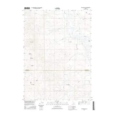
2017 Map of Thatcher Hill
USGS Topo · Published 2017About this map
The Bear River meanders through the central valley of this 2017 survey, creating a lush corridor between the Portneuf Range to the west and the rising slopes of Gem Valley and Gentile Valley to the east. Agriculture and water management are central to the landscape, evidenced by the Gentile Valley Canal and numerous drainage creeks such as Densmore Cr and Burton Cr that feed into the river system. The settlement pattern is largely rural and clustered near the base of the mountains, with Thatcher and Thatcher Gem serving as local hubs for the surrounding farmsteads.
Find a feature on this map
36 named features on this map. Tap any name to fly to it.
Don’t see what you’re looking for? This feature index may not catch every label — zoom into the map to look around manually.
Map Details
Editions of this 2017 Thatcher Hill Map
This is the sole edition of this map. No revisions or reprints were ever made.
Other maps of this area

1915 · Preston
USGS Topo · 1:96,000

1918 · Preston
USGS Topo · 1:125,000

1948 · Bancroft
USGS Topo · 1:62,500

1948 · Soda Springs
USGS Topo · 1:62,500

1949 · Bancroft
USGS Topo · 1:62,500

1949 · Soda Springs
USGS Topo · 1:62,500

1955 · Preston
USGS Topo · 1:250,000

1958 · Preston
USGS Topo · 1:250,000

1962 · Preston
USGS Topo · 1:250,000
1969 · Treasureton
USGS Topo · 1:24,000