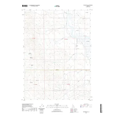
2020 Map of Thatcher Hill
USGS Topo · Published 2020About this map
The Bear River meanders through the heart of Gentile Valley, marking a landscape where high-desert agriculture and rugged terrain meet at the border of Caribou and Franklin Counties. The valley floor is defined by a complex network of irrigation and infrastructure, including the Gentile Valley Canal and several local roads like River Road and Gentile Valley Road that follow the natural contours of the water. To the west, the topography rises sharply into the Portneuf Range, characterized by deep incisions like Left Fork Mill Canyon and Right Fork Mill Canyon. Local history is anchored by the Thatcher Cemetery and the presence of the W E Ranch Airport, suggesting a sparsely populated ranching community. The map also documents geographic landmarks such as Thatcher Hill and Gem Valley, providing a detailed look at the land use and drainage patterns of this southeastern Idaho corridor.
Find a feature on this map
35 named features on this map. Tap any name to fly to it.
Don’t see what you’re looking for? This feature index may not catch every label — zoom into the map to look around manually.
Map Details
Editions of this 2020 Thatcher Hill Map
This is the sole edition of this map. No revisions or reprints were ever made.
Other maps of this area

1915 · Preston
USGS Topo · 1:96,000

1918 · Preston
USGS Topo · 1:125,000

1948 · Bancroft
USGS Topo · 1:62,500

1948 · Soda Springs
USGS Topo · 1:62,500

1949 · Bancroft
USGS Topo · 1:62,500

1949 · Soda Springs
USGS Topo · 1:62,500

1955 · Preston
USGS Topo · 1:250,000

1958 · Preston
USGS Topo · 1:250,000

1962 · Preston
USGS Topo · 1:250,000
1969 · Treasureton
USGS Topo · 1:24,000