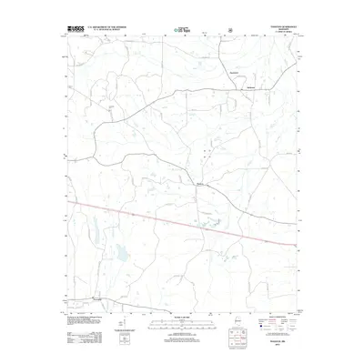
2012 Map of Thaxton
USGS Topo · Published 2012About this map
The town of Thaxton serves as a central hub in this Mississippi landscape, which is defined by a dense network of country roads and local drainage basins. Small rural communities like Hurricane and Esperanza sit to the north, connected by routes such as Hurricane Bnd and White Rd. For those tracing local genealogy or land use, the Laodicea Cem stands near the headwaters of Mill Cr, while the southern portion of the quadrangle is anchored by Toccopola. The terrain is deeply etched by a system of creeks and branches, including the curiously named Buttermilk Br and the winding Cane Cr. These watercourses dictated the placement of early homesteads and the development of the primary transit corridors that eventually became the modern road network shown here.
Find a feature on this map
63 named features on this map. Tap any name to fly to it.
Don’t see what you’re looking for? This feature index may not catch every label — zoom into the map to look around manually.
Map Details
Editions of this 2012 Thaxton Map
This is the sole edition of this map. No revisions or reprints were ever made.
Other maps of this area

1942 · Denmark
USGS Topo · 1:62,500

1943 · Denmark
USGS Topo · 1:62,500

1949 · New Albany
USGS Topo · 1:62,500

1951 · New Albany
USGS Topo · 1:62,500

1956 · Tupelo
USGS Topo · 1:250,000

1958 · Tupelo
USGS Topo · 1:250,000

1972 · Randolph
USGS Topo · 1:24,000
1972 · Southwest Pontotoc
USGS Topo · 1:24,000
1972 · Tula
USGS Topo · 1:24,000

1980 · Northwest Pontotoc
USGS Topo · 1:24,000