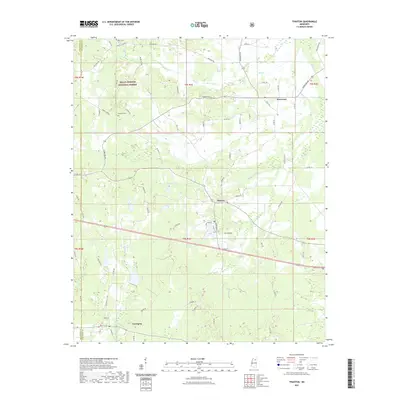
2021 Map of Thaxton
USGS Topo · Published 2021About this map
Thaxton and Toccopola anchor this rural landscape in western Pontotoc County, where the terrain is defined by the headwaters of several key drainage systems. The northern portion of the map is dominated by the Holly Springs National Forest, a wooded expanse where family names persist on roads like Graham Rd and Benjamin Rd. Evidence of the area's long-standing community structure is found at Union Cem and Laodicea Cem, reflecting the early centers of local life. The map illustrates a complex network of creeks including Buttermilk Br, Cane Cr, and Toccopola Cr, which have historically dictated the placement of homesteads and roads. The small settlement of Hurricane further East highlights the dispersed but persistent residential pattern characteristic of this Mississippi hill country region.
Find a feature on this map
73 named features on this map. Tap any name to fly to it.
Don’t see what you’re looking for? This feature index may not catch every label — zoom into the map to look around manually.
Map Details
Editions of this 2021 Thaxton Map
This is the sole edition of this map. No revisions or reprints were ever made.
Other maps of this area

1942 · Denmark
USGS Topo · 1:62,500

1943 · Denmark
USGS Topo · 1:62,500

1949 · New Albany
USGS Topo · 1:62,500

1951 · New Albany
USGS Topo · 1:62,500

1956 · Tupelo
USGS Topo · 1:250,000

1958 · Tupelo
USGS Topo · 1:250,000

1972 · Randolph
USGS Topo · 1:24,000
1972 · Southwest Pontotoc
USGS Topo · 1:24,000
1972 · Tula
USGS Topo · 1:24,000

1980 · Northwest Pontotoc
USGS Topo · 1:24,000