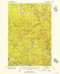
1952 Map of Thayer
USGS Topo · Published 1954About this map
The Chicago and North Western railway corridors define the development of this Upper Peninsula landscape during the early 1950s. Isolated logging and rail stops like Thayer and Gogebic Station represent the sparse settlement pattern within the Ottawa National Forest, where industrial activity is marked by various gravel pits and named spurs such as Blacks Spur. The terrain is characterized by a dense network of glacial lakes and river systems, including the South Branch Ontonagon River and the South Branch Presque Isle River. Notable landmarks such as the Matchwood Lookout Tower and Watersmeet Lookout Tower highlight the importance of fire observation in this heavily timbered region. Hydrological features like Kakabika Falls and Wolverine Falls punctuate the drainage basins, while large bodies of water like Beatons Lake and Sucker Lake provide significant geographic anchors between the townships of Marenisco and Watersmeet.
Find a feature on this map
81 named features on this map. Tap any name to fly to it.
Don’t see what you’re looking for? This feature index may not catch every label — zoom into the map to look around manually.
Map Details
Editions of this 1952 Thayer Map
4 editions found

Other maps of this area

1938 · Phelps
USGS Topo · 1:48,000

1939 · Trout Lake
USGS Topo · 1:48,000

1946 · Star Lake
USGS Topo · 1:48,000

1946 · Trout Lake
USGS Topo · 1:48,000

1949 · Trout Lake
USGS Topo · 1:48,000

1949 · Rockland
USGS Topo · 1:62,500

1950 · Phelps
USGS Topo · 1:48,000

1950 · Star Lake
USGS Topo · 1:48,000

1951 · Rockland
USGS Topo · 1:62,500

1952 · Watersmeet
USGS Topo · 1:62,500