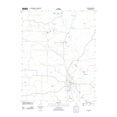
2011 Map of Thayer
USGS Topo · Published 2011About this map
Thayer serves as the primary hub in this Missouri Ozarks landscape, where the Warm Fork Spring River and numerous tributaries like Twomile Creek and English Creek define the local geography. The map captures a high degree of local nomenclature through its numerous named hollows and springs, such as Camp Jefferson Hollow, Crazy Spring Hollow, and Spout Spring. To the west, the presence of Grand Gulf State Park highlights a significant geological feature, while the area surrounding the town is marked by historic neighborhood labels including Green Town, Old Town, and the settlement of Shelby. Genealogists will find particular value in the clearly marked burial sites, including Walker Cemetery, Childress Cemetery, and Davis Cemetery, which are scattered throughout the ridge-and-valley terrain near landmarks like Turkeypen Ridge and Deerlick Ridge.
Find a feature on this map
78 named features on this map. Tap any name to fly to it.
Don’t see what you’re looking for? This feature index may not catch every label — zoom into the map to look around manually.
Map Details
Editions of this 2011 Thayer Map
This is the sole edition of this map. No revisions or reprints were ever made.
Other maps of this area

1943 · Thayer
USGS Topo · 1:62,500

1944 · Couch
USGS Topo · 1:62,500

1946 · Thayer
USGS Topo · 1:62,500

1946 · Couch
USGS Topo · 1:62,500

1957 · Poplar Bluff
USGS Topo · 1:250,000

1959 · Poplar Bluff
USGS Topo · 1:250,000

1960 · Poplar Bluff
USGS Topo · 1:250,000

1962 · Mammoth Spring
USGS Topo · 1:24,000
1962 · Camp
USGS Topo · 1:24,000
1968 · Wirth
USGS Topo · 1:24,000