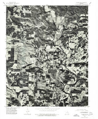
1976 Map of Thayer SE
USGS Topo · Published 1977About this map
Thayer dominates the southern portion of this Missouri landscape, appearing as a dense cluster of development just north of the state line. This 1976 orthophotoquad provides an unfiltered aerial perspective of the region's land use, contrasting the town's grid with the surrounding rural patchwork. The Spring River meanders through the central and eastern sections of the quadrangle, its path marked by dark riparian vegetation that cuts through a mosaic of cleared agricultural fields and wooded hillsides. The imagery reveals the complex relationship between the valley floor's fertile tracts and the more heavily timbered uplands typical of the Oregon County terrain. For those researching local history, this photographic record captures the exact footprint of residential and commercial growth during the mid-1970s, showing the extent of clearing and the established road network connecting the river valley to the town center.
Find a feature on this map
2 named features on this map. Tap any name to fly to it.
Don’t see what you’re looking for? This feature index may not catch every label — zoom into the map to look around manually.
Map Details
Editions of this 1976 Thayer SE Map
This is the sole edition of this map. No revisions or reprints were ever made.
Other maps of this area

1943 · Thayer
USGS Topo · 1:62,500

1944 · Couch
USGS Topo · 1:62,500

1946 · Thayer
USGS Topo · 1:62,500

1946 · Couch
USGS Topo · 1:62,500

1957 · Poplar Bluff
USGS Topo · 1:250,000

1959 · Poplar Bluff
USGS Topo · 1:250,000

1960 · Poplar Bluff
USGS Topo · 1:250,000

1962 · Mammoth Spring
USGS Topo · 1:24,000
1962 · Camp
USGS Topo · 1:24,000
1968 · Wirth
USGS Topo · 1:24,000