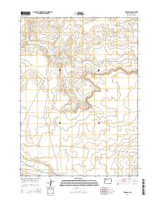
2014 Map of The Basin
USGS Topo · Published 2014About this map
The Basin serves as the central landform of this high desert region in Malheur County, where the drainage patterns of Dry Cr and Dry Crk carve through the arid plateau. The landscape is defined by its sparse infrastructure, primarily supporting ranching and resource access through a network of remote roads and tracks. The presence of the Old Idh Hwy and the specialized Well Spur suggests a history of transit and water management in a territory where such resources are critical. Along the southern edge, the terrain shifts near the riparian corridor of Rattlesnake Cr, accessed by the unpaved Rattlesnake Creek Rd. This survey documents the modern state of the Public Land Survey System grid across these high-elevation basins, capturing the intersection of section lines and the natural topography.
Find a feature on this map
14 named features on this map. Tap any name to fly to it.
Don’t see what you’re looking for? This feature index may not catch every label — zoom into the map to look around manually.
Map Details
Editions of this 2014 The Basin Map
This is the sole edition of this map. No revisions or reprints were ever made.
Other maps of this area

1955 · Jordan Valley
USGS Topo · 1:250,000

1957 · Jordan Valley
USGS Topo · 1:250,000

1958 · Jordan Valley
USGS Topo · 1:250,000

1972 · Rome
USGS Topo · 1:24,000
1972 · Scott Reservoir
USGS Topo · 1:24,000
1972 · Burns Junction
USGS Topo · 1:24,000

1979 · Rockhouse Reservoir
USGS Topo · 1:24,000

1979 · Bowden Ranch
USGS Topo · 1:24,000

1979 · Anderson Reservoir
USGS Topo · 1:24,000

1979 · Flat Top Mtn SE
USGS Topo · 1:24,000