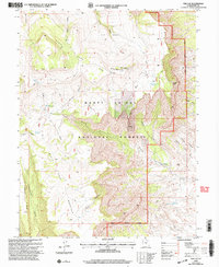
2001 Map of The Cap
USGS Topo · Published 2004About this map
Manti-La Sal National Forest dominates this landscape in Emery County, where high plateaus and deep canyons define the transition between the North Horn Mountain Ridge and the lower East Rim. The terrain is marked by family-named landmarks such as Biddlecome Ridge and Nielson Swale, alongside evidence of resource management in the Ferron Ranger District. Water management is central to this environment, with high-elevation catchments like West Clawson Reservoir and uniquely named points such as Baseball Pond and Barewire Pond. The presence of the Anderson Mine and various drill holes suggests a history of mineral exploration and industrial interest within the canyon system. An extensive network of 4wd tracks and a major pipeline traverse the rugged topography, illustrating the infrastructure required to navigate the canyons of South Horn Mountain and Killpack Canyon.
Find a feature on this map
34 named features on this map. Tap any name to fly to it.
Don’t see what you’re looking for? This feature index may not catch every label — zoom into the map to look around manually.
Map Details
Editions of this 2001 The Cap Map
This is the sole edition of this map. No revisions or reprints were ever made.
Other maps of this area

1885 · Manti
USGS Topo · 1:250,000

1895 · Manti
USGS Topo · 1:250,000

1922 · Wasatch
USGS Topo · 1:31,680

1923 · Castle Dale
USGS Topo · 1:62,500

1923 · Hiawatha
USGS Topo · 1:62,500

1925 · Castle Dale
USGS Topo · 1:62,500

1925 · Hiawatha
USGS Topo · 1:62,500

1956 · Price
USGS Topo · 1:250,000

1960 · Price
USGS Topo · 1:250,000

1962 · Price
USGS Topo · 1:250,000