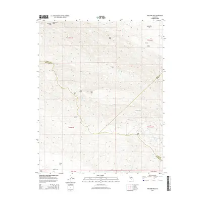
2015 Map of The Dark Hole
USGS Topo · Published 2015About this map
The Dark Hole names a distinctive topographic depression in the high ridges of the Diablo Range, where the borders of Fresno, Monterey, and Kings counties converge. This 2015 survey illuminates a landscape defined by sharp elevation changes and vital water sources in a semi-arid environment. Prominent peaks such as Castle Mtn, Black Mtn, and Table Mtn anchor the terrain, while numerous seasonal springs like Vaquero Spring, Sugar Tail Spring, and Spring in Bush indicate the critical role of hydrology for local ranching and land use. The map reveals the intricate drainage patterns of Avenal Cr and Zapato Chino Cr as they cut through the Kreyenhagen Hills and along Reef Ridge. The isolated Turkey Flat and Oak Flat provide level breaks in the otherwise steep canyons, reached primarily by the winding Turkey Flat Rd.
Find a feature on this map
37 named features on this map. Tap any name to fly to it.
Don’t see what you’re looking for? This feature index may not catch every label — zoom into the map to look around manually.
Map Details
Editions of this 2015 The Dark Hole Map
This is the sole edition of this map. No revisions or reprints were ever made.
Other maps of this area

1912 · Coalinga
USGS Topo · 1:125,000

1914 · Cholame
USGS Topo · 1:125,000

1915 · Cholame
USGS Topo · 1:125,000

1917 · Cholame
USGS Topo · 1:125,000

1930 · Canoas Creek
USGS Topo · 1:31,680

1934 · The Dark Hole
USGS Topo · 1:31,680

1934 · Reef Ridge
USGS Topo · 1:31,680

1934 · Canoas Creek
USGS Topo · 1:31,680

1936 · Kreyenhagen Hills
USGS Topo · 1:31,680
1937 · Reef Ridge
USGS Topo · 1:31,680