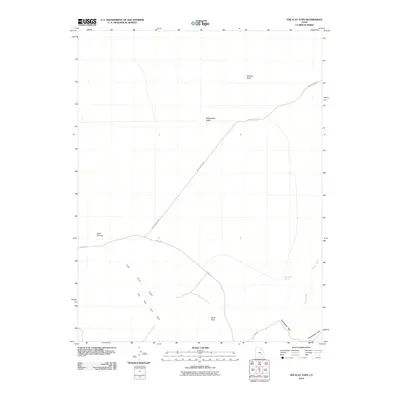
2010 Map of The Flat Tops
USGS Topo · Published 2010About this map
The Flat Tops and the surrounding desert landscape of Emery County are defined by isolated buttes and seasonal water sources in this 2010 topographic study. The area is marked by significant topographical landmarks such as Wildcat Butte, Rattlesnake Butte, and Little Flat Top. Movement through this arid terrain is facilitated by the Flint Trl and Saucer Basin Rd, which navigate between the elevated plateaus and drainage systems like Dugout Wash. A vital point of interest for those studying the geography of the region is Sweetwater Spring, located near the base of Sweetwater Reef. The map illustrates a remote landscape where travel remains confined to specific trails and roads that follow the natural contours of the land, such as the path toward Spire Point.
Find a feature on this map
10 named features on this map. Tap any name to fly to it.
Don’t see what you’re looking for? This feature index may not catch every label — zoom into the map to look around manually.
Map Details
Editions of this 2010 The Flat Tops Map
This is the sole edition of this map. No revisions or reprints were ever made.
Other maps of this area

1885 · San Rafael
USGS Topo · 1:250,000

1953 · Tidwell 3 NW
USGS Topo · 1:24,000

1953 · Temple Mtn
USGS Topo · 1:62,500

1954 · Stinking Spring Creek 4 NE
USGS Topo · 1:24,000

1954 · Stinking Spring Creek 4 SE
USGS Topo · 1:24,000

1956 · Salina
USGS Topo · 1:250,000

1960 · Salina
USGS Topo · 1:250,000

1962 · Salina
USGS Topo · 1:250,000

1963 · Robbers Roost Canyon
USGS Topo · 1:62,500
1963 · Hanksville
USGS Topo · 1:62,500