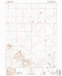
1986 Map of The Flat Tops
USGS Topo · Published 1987About this map
The Flat Tops and The Big Flat Tops dominate this high desert landscape on the border of Emery and Wayne counties. The terrain is defined by isolated formations like Wildcat Butte, Rattlesnake Butte, and Little Flat Top, which rise above a network of drainages and seasonal water sources. The map identifies Sweetwater Spring and the Sweetwater Wash, critical points of interest in an arid environment where water dictates the location of human activity. Evidence of ranching and early resource exploration is seen in the notation of a Dugout and several drill holes marked as "DH." To the south, the geological transition is marked by the Reef and Spire Point, showing a complex system of cliffs and canyons. This provisional survey captures the area as it was documented through field checks in the mid-1980s, preserving a record of the remote back-country before modern digital updates.
Find a feature on this map
14 named features on this map. Tap any name to fly to it.
Don’t see what you’re looking for? This feature index may not catch every label — zoom into the map to look around manually.
Map Details
Editions of this 1986 The Flat Tops Map
This is the sole edition of this map. No revisions or reprints were ever made.
Other maps of this area

1885 · San Rafael
USGS Topo · 1:250,000

1953 · Tidwell 3 NW
USGS Topo · 1:24,000

1953 · Temple Mtn
USGS Topo · 1:62,500

1954 · Stinking Spring Creek 4 NE
USGS Topo · 1:24,000

1954 · Stinking Spring Creek 4 SE
USGS Topo · 1:24,000

1956 · Salina
USGS Topo · 1:250,000

1960 · Salina
USGS Topo · 1:250,000

1962 · Salina
USGS Topo · 1:250,000

1963 · Robbers Roost Canyon
USGS Topo · 1:62,500
1963 · Hanksville
USGS Topo · 1:62,500