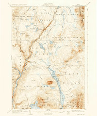
1907 Map of The Forks
USGS Topo · Published 1937About this map
The Forks marks the convergence of the Kennebec and Dead Rivers, anchoring a region of the Maine north woods shaped by early 20th-century logging and rail transport. The Maine Central railroad corridor tracks along the eastern shore of the expansive Indian Pond, where the Squirtgun Dam and other controls regulated the flow of water for industrial use. Land divisions like the 10000 Acre Tract and Moxie Gore illustrate the large-scale timber interests that dominated the era. Terrain is defined by prominent peaks such as Mosquito Mtn and Bald Mountain, while a network of primitive routes like the Shirley Tote Road provided essential passage through the dense forest. Numerous small logging camps are scattered throughout the quadrangle, particularly near water bodies like Black Brook Pond and Knights Pond, reflecting the seasonal industry that drove the local economy before modern infrastructure replaced these isolated outposts.
Find a feature on this map
78 named features on this map. Tap any name to fly to it.
Don’t see what you’re looking for? This feature index may not catch every label — zoom into the map to look around manually.
Map Details
Editions of this 1907 The Forks Map
4 editions found
Other maps of this area

1903 · Bingham
USGS Topo · 1:62,500

1905 · Bingham
USGS Topo · 1:62,500

1905 · The Forks
USGS Topo · 1:62,500

1907 · The Forks
USGS Topo · 1:62,500

1920 · Moosehead Lake
USGS Topo · 1:62,500

1921 · Brassua Lake
USGS Topo · 1:62,500

1922 · Moosehead Lake
USGS Topo · 1:62,500

1922 · Long Pond
USGS Topo · 1:62,500

1923 · Brassua Lake
USGS Topo · 1:62,500

1924 · Long Pond
USGS Topo · 1:62,500