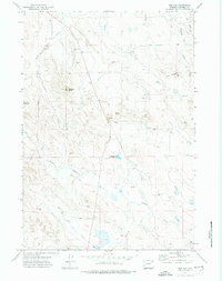
1971 Map of The Gap
USGS Topo · Published 1974About this map
Antelope Butte and Rocky Butte anchor this high-plains landscape in Campbell County, where the topography is defined by the sharp drop-off at The Gap. This early 1970s survey documents a region utilized for ranching and resource extraction, evidenced by the numerous Drill Hole locations and Gravel Pit sites scattered across the terrain. Rural education is marked by the presence of the Gap Sch, providing a rare point of social infrastructure in this sparsely populated area. The drainage network is critical to this semi-arid environment, with Tisdale Creek and Duck Nest Creek winding through the draws. Man-made water management is visible at the Mary Alice Reservoir and Rourke Reservoir, which likely supported livestock along with features like the Shearing Pen Draw near the eastern boundary.
Find a feature on this map
16 named features on this map. Tap any name to fly to it.
Don’t see what you’re looking for? This feature index may not catch every label — zoom into the map to look around manually.
Map Details
Editions of this 1971 The Gap Map
2 editions found
Other maps of this area

1954 · Gillette
USGS Topo · 1:250,000

1955 · Gillette
USGS Topo · 1:250,000

1958 · Gillette
USGS Topo · 1:250,000

1962 · Gillette
USGS Topo · 1:250,000

1971 · Scaper Reservoir
USGS Topo · 1:24,000

1971 · Coyote Draw
USGS Topo · 1:24,000

1971 · The Gap SW
USGS Topo · 1:24,000

1971 · Gillette East
USGS Topo · 1:24,000
1971 · Saddle Horse Butte
USGS Topo · 1:24,000
1971 · Appel Butte
USGS Topo · 1:24,000