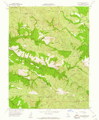
1959 Map of The Geysers
USGS Topo · Published 1961About this map
Geothermal energy and quicksilver mining define this late 1950s landscape across the Mayacmas Mountains. The map documents the early infrastructure of The Geysers, where a powerplant and the Geysers Resort are situated along Big Sulphur Creek. The region’s mercury mining legacy is visible through numerous operations, including the Buckman Mines with its housing units and headquarters, the Cloverdale Mine, and the Socrates Mine. Further south, the small settlement of Mercuryville sits near the Culver Bear Mine.
Find a feature on this map
61 named features on this map. Tap any name to fly to it.
Don’t see what you’re looking for? This feature index may not catch every label — zoom into the map to look around manually.
Map Details
Editions of this 1959 The Geysers Map
3 editions found
Other maps of this area

1920 · Healdsburg
USGS Topo · 1:62,500

1921 · Kelseyville
USGS Topo · 1:62,500

1927 · Calistoga
USGS Topo · 1:62,500

1933 · Healdsburg
USGS Topo · 1:48,000

1940 · Healdsburg
USGS Topo · 1:62,500

1943 · Calistoga
USGS Topo · 1:62,500

1943 · Kelseyville
USGS Topo · 1:62,500

1945 · Calistoga
USGS Topo · 1:62,500

1945 · Lower Lake
USGS Topo · 1:62,500

1947 · Santa Rosa
USGS Topo · 1:250,000