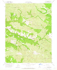
1959 Map of The Geysers
USGS Topo · Published 1965About this map
Industrial development in the Maacamas Mountains is prominently displayed on this survey, highlighting the geothermal and mining activity of the late 1950s. The landscape is defined by the steaming activity at The Geysers (Steam Wells) and the nearby Geysers Resort, where early energy infrastructure like the Powerplant began to emerge along the banks of Big Sulphur Creek. Geologists and historians can trace the concentration of mineral extraction through a network of adits and mine sites, including the Buckman Mines and Mercuryville. The terrain transitions from these industrial corridors to the high ridges of Geyser Peak and Burned Mountain. This map also preserves the locations of early rural habitations such as Caldwell Ranch and Binkley Ranch, providing a window into the remote settlement patterns within the rugged borderlands of Sonoma and Lake Counties.
Find a feature on this map
66 named features on this map. Tap any name to fly to it.
Don’t see what you’re looking for? This feature index may not catch every label — zoom into the map to look around manually.
Map Details
Editions of this 1959 The Geysers Map
3 editions found
Other maps of this area

1920 · Healdsburg
USGS Topo · 1:62,500

1921 · Kelseyville
USGS Topo · 1:62,500

1927 · Calistoga
USGS Topo · 1:62,500

1933 · Healdsburg
USGS Topo · 1:48,000

1940 · Healdsburg
USGS Topo · 1:62,500

1943 · Calistoga
USGS Topo · 1:62,500

1943 · Kelseyville
USGS Topo · 1:62,500

1945 · Calistoga
USGS Topo · 1:62,500

1945 · Lower Lake
USGS Topo · 1:62,500

1947 · Santa Rosa
USGS Topo · 1:250,000