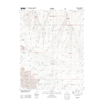
2013 Map of The Glade
USGS Topo · Published 2013About this map
San Juan National Forest defines the rugged character of this high-elevation landscape in Dolores County, where a complex network of water management features highlights the importance of resource control in the arid Southwest. The terrain is marked by numerous draws and arroyos, including West Branch Pine Arroyo and Rock Spring Draw, which feed a series of numbered catchments like Big Water Reservoir Number Six and Wild Bill Number Five Reservoir. These reservoirs, along with Main Reservoir and Corral Lake, represent a significant engineering footprint within the forest, likely serving regional livestock or forest management needs. The distinct topographical features of The Glade and Glade Point offer a clear view of the plateau and canyon transitions, specifically where the land drops into Dolores Canyon and Glade Canyon.
Find a feature on this map
95 named features on this map. Tap any name to fly to it.
Don’t see what you’re looking for? This feature index may not catch every label — zoom into the map to look around manually.
Map Details
Editions of this 2013 The Glade Map
This is the sole edition of this map. No revisions or reprints were ever made.
Other maps of this area

1949 · Joe Davis Hill
USGS Topo · 1:24,000

1950 · Joe Davis Hill
USGS Topo · 1:24,000

1956 · Cortez
USGS Topo · 1:250,000

1958 · Cortez
USGS Topo · 1:250,000

1959 · Cortez
USGS Topo · 1:250,000

1962 · Cortez
USGS Topo · 1:250,000
1964 · Dawson Draw
USGS Topo · 1:24,000

1964 · Glade Mountain
USGS Topo · 1:24,000

1964 · Mc Kenna Peak
USGS Topo · 1:24,000
1964 · Secret Canyon
USGS Topo · 1:24,000