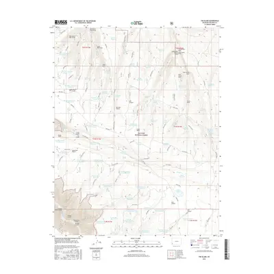
2016 Map of The Glade
USGS Topo · Published 2016About this map
San Juan National Forest defines much of this landscape in Dolores County, where an extensive network of water management features reveals the importance of ranching and resource conservation in this high-altitude environment. The area is marked by numerous man-made catchments, including the Big Water Reservoir Number Three, Fader Reservoir, and Muddy Reservoir, which sit among naturally occurring draws and arroyos. Landforms like Glade Point and Wild Horse Point provide significant verticality, overlooking the deep incisions of Glade Canyon and Wolf Den Canyon. Historic natural water sources such as Fader Spring, White Sands Spring, and Cottonwood Spring are carefully noted, indicating their historical value to both early settlers and forest management. This 2016 survey illustrates how the landscape is divided into named areas like The Glade, connected by forest roads such as Doe Springs.
Find a feature on this map
97 named features on this map. Tap any name to fly to it.
Don’t see what you’re looking for? This feature index may not catch every label — zoom into the map to look around manually.
Map Details
Editions of this 2016 The Glade Map
This is the sole edition of this map. No revisions or reprints were ever made.
Other maps of this area

1949 · Joe Davis Hill
USGS Topo · 1:24,000

1950 · Joe Davis Hill
USGS Topo · 1:24,000

1956 · Cortez
USGS Topo · 1:250,000

1958 · Cortez
USGS Topo · 1:250,000

1959 · Cortez
USGS Topo · 1:250,000

1962 · Cortez
USGS Topo · 1:250,000
1964 · Dawson Draw
USGS Topo · 1:24,000

1964 · Glade Mountain
USGS Topo · 1:24,000

1964 · Mc Kenna Peak
USGS Topo · 1:24,000
1964 · Secret Canyon
USGS Topo · 1:24,000