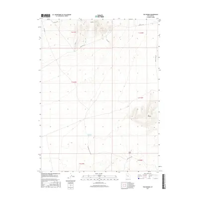
2017 Map of The Hogback
USGS Topo · Published 2017About this map
Keg Mtn dominates the northern reaches of this high-desert landscape in Juab County, while the distinctive ridge of The Hogback rises in the southeast. This 2017 topographic survey highlights a network of primitive and local roads that crisscross the arid terrain, including Jericho Callao Rd and Wilson Camp Rd, which likely served as crucial corridors for ranching and mineral exploration in the region's earlier history. The presence of Hogback Reservoir in the central basin and Crater Bench to the south indicates the essential role of water management and volcanic geology in shaping the use of this remote Utah territory. A complex system of tracks, such as Baker Hot Springs Rd and Keg Pass Rd, connects the scattered peaks and benches, providing a detailed record of the accessibility of these public lands during the early 21st century.
Find a feature on this map
18 named features on this map. Tap any name to fly to it.
Don’t see what you’re looking for? This feature index may not catch every label — zoom into the map to look around manually.
Map Details
Editions of this 2017 The Hogback Map
This is the sole edition of this map. No revisions or reprints were ever made.
Other maps of this area

1885 · Sevier Desert
USGS Topo · 1:250,000

1953 · Delta
USGS Topo · 1:250,000

1958 · Delta
USGS Topo · 1:250,000

1962 · Delta
USGS Topo · 1:250,000

1971 · Baker Hot Springs
USGS Topo · 1:24,000

1971 · Picture Rock Hills
USGS Topo · 1:24,000

1971 · Drum Mts Well
USGS Topo · 1:24,000

1971 · Crater Bench Reservoir
USGS Topo · 1:24,000
1971 · Keg Mtn Ranch
USGS Topo · 1:24,000

1971 · Fumarole Butte
USGS Topo · 1:24,000