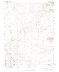
1971 Map of The Hogback
USGS Topo · Published 1974About this map
The Apishapa River cuts through this high plains landscape of Las Animas County, defined by the prominent ridge of The Hogback. In the early 1970s, the area retained a distinctly industrial and agricultural character, evidenced by the irrigation network of the Borrego Ditch and Saiz Ditch. Transportation history is layered across the terrain, where the active Colorado and Southern railroad line runs parallel to an Old Railroad Grade in the northwest, tracing the evolution of rail movement through this part of southern Colorado. The landscape is dotted with several water bodies including Freeburrow Lake, Dupont Lake, and Jones Lake. Scattered Prospects and Gravel Pits indicate localized extraction efforts alongside the winding courses of Salado Creek and Arroyo Del Agua.
Find a feature on this map
21 named features on this map. Tap any name to fly to it.
Don’t see what you’re looking for? This feature index may not catch every label — zoom into the map to look around manually.
Map Details
Editions of this 1971 The Hogback Map
2 editions found
Other maps of this area

1891 · Walsenburg
USGS Topo · 1:125,000

1891 · Spanish Peaks
USGS Topo · 1:125,000

1891 · Apishapa
USGS Topo · 1:125,000

1892 · Elmoro
USGS Topo · 1:125,000

1893 · Spanish Peaks
USGS Topo · 1:125,000

1893 · Apishapa
USGS Topo · 1:125,000

1893 · Elmoro
USGS Topo · 1:125,000

1894 · Walsenburg
USGS Topo · 1:125,000

1895 · Spanish Peaks
USGS Topo · 1:125,000

1897 · Walsenburg
USGS Topo · 1:125,000