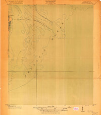
1919 Map of The Jetties
USGS Topo · Published 1919About this map
Morris Island and its northernmost tip at Cummings Point anchor this coastal survey, which documents the critical maritime engineering protecting the entrance to Charleston's harbor. Produced in cooperation with the War Department and the Army Corps of Engineers, the map details the massive underwater structures of the North Jetty and South Jetty as they extend into the Atlantic Ocean. These harbor defenses were vital for maintaining navigable channels through the shifting sands of the South Carolina coast. The map provides precise bathymetric data, showing the depth contours off the shore at five, ten, and twenty feet below mean low water. This specialized study focuses on the intersection of land and sea, where man-made infrastructure meets the natural forces of the Atlantic.
Find a feature on this map
5 named features on this map. Tap any name to fly to it.
Don’t see what you’re looking for? This feature index may not catch every label — zoom into the map to look around manually.
Map Details
Editions of this 1919 The Jetties Map
4 editions found
Other maps of this area

1919 · The Jetties
USGS Topo · 1:21,120

1919 · Capers Island
USGS Topo · 1:21,120

1919 · Charleston
USGS Topo · 1:21,120

1919 · James Island
USGS Topo · 1:21,120

1919 · Fort Moultrie
USGS Topo · 1:21,120

1943 · Capers Island
USGS Topo · 1:24,000

1943 · Fort Moultrie
USGS Topo · 1:24,000

1943 · James Island
USGS Topo · 1:24,000

1948 · James Island
USGS Topo · 1:250,000
1948 · Charleston
USGS Topo · 1:24,000