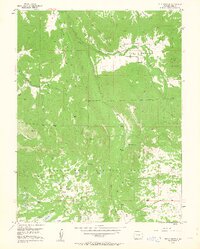
1955 Map of The Meadows
USGS Topo · Published 1963About this map
Grand Mesa National Forest defines the landscape of this mid-century survey, revealing a high-elevation environment managed for water and grazing. Irrigation infrastructure is prominent throughout the terrain, with family-named water features like McKelvie Res and Labbe Res alongside the Salt Creek Ditch and Rock Creek Ditch. These diversions illustrate the critical role of water management in supporting the region's agricultural interests.
Find a feature on this map
45 named features on this map. Tap any name to fly to it.
Don’t see what you’re looking for? This feature index may not catch every label — zoom into the map to look around manually.
Map Details
Editions of this 1955 The Meadows Map
8 editions found
Other maps of this area

1955 · Collbran
USGS Topo · 1:24,000

1955 · Grand Mesa
USGS Topo · 1:24,000

1955 · The Meadows
USGS Topo · 1:24,000

1957 · Leadville
USGS Topo · 1:250,000

1959 · Leadville
USGS Topo · 1:250,000

1960 · Leadville
USGS Topo · 1:250,000

1960 · Leon Peak
USGS Topo · 1:24,000
1960 · Hawxhurst Creek
USGS Topo · 1:24,000

1960 · South Mamm Peak
USGS Topo · 1:24,000

1961 · Porter Mountain
USGS Topo · 1:24,000