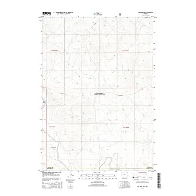
2015 Map of The Nose East
USGS Topo · Published 2015About this map
Thunder Basin National Grassland dominates this high plains landscape, where drainage patterns define the movement of water across the open range. The southern boundary of the map follows the winding course of the Cheyenne River, which is joined by local tributaries including Lodgepole Cr and Coyote Cr. These seasonal watercourses and the Butte Reservoir provided vital watering points for livestock in a region historically shaped by cattle ranching. Landmark features like The Nose and Graham Draw serve as essential navigational points in the expansive terrain of Weston and Niobrara counties. A sparse network of ranching roads, such as Grieves Rd and Cheyenne River Rd, provides the primary access through the grid-surveyed sections of the public land system.
Find a feature on this map
15 named features on this map. Tap any name to fly to it.
Don’t see what you’re looking for? This feature index may not catch every label — zoom into the map to look around manually.
Map Details
Editions of this 2015 The Nose East Map
This is the sole edition of this map. No revisions or reprints were ever made.
Other maps of this area

1899 · Newcastle
USGS Topo · 1:125,000

1901 · Newcastle
USGS Topo · 1:125,000

1955 · Newcastle
USGS Topo · 1:250,000

1958 · Newcastle
USGS Topo · 1:250,000

1979 · Newcastle
USGS Topo · 1:100,000

1981 · Horseshoe Bend
USGS Topo · 1:24,000

1981 · Threemile Butte
USGS Topo · 1:24,000

1981 · Garland Draw
USGS Topo · 1:24,000

1981 · Lance Creek
USGS Topo · 1:100,000
1982 · Morrisey
USGS Topo · 1:24,000