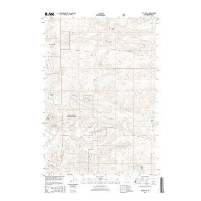
2015 Map of The Notch
USGS Topo · Published 2015About this map
Black Hills National Forest land defines this section of the Bear Lodge Mountains, where numerous water sources like Pearson Spring, Knoff Spring, and Mitchell Spring indicate a landscape managed for both timber and grazing. The topography is marked by significant drainages and high points, including the namesake gap at The Notch and the flat-topped Little Table Mtn to the southeast. Historically significant routes for forestry and ranching, such as the Bear Lodge Truck Trl and Bearlodge Br 4P, provide access through the complex terrain of Lucky Gulch and Oak Creek Basin. The distribution of features like Gets Reservoir and Williams Spring reflects the critical importance of water management in this high-elevation Wyoming environment.
Find a feature on this map
51 named features on this map. Tap any name to fly to it.
Don’t see what you’re looking for? This feature index may not catch every label — zoom into the map to look around manually.
Map Details
Editions of this 2015 The Notch Map
This is the sole edition of this map. No revisions or reprints were ever made.
Other maps of this area

1901 · Aladdin
USGS Topo · 1:125,000

1903 · Aladdin
USGS Topo · 1:125,000

1954 · Gillette
USGS Topo · 1:250,000

1955 · Gillette
USGS Topo · 1:250,000

1957 · Mona
USGS Topo · 1:62,500

1957 · Colony
USGS Topo · 1:62,500

1958 · Gillette
USGS Topo · 1:250,000

1958 · Beulah
USGS Topo · 1:62,500

1962 · Gillette
USGS Topo · 1:250,000
1979 · Devils Tower
USGS Topo · 1:100,000