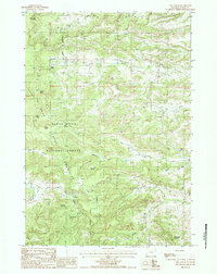
1984 Map of The Notch
USGS Topo · Published 1985About this map
The Bear Lodge Mountains dominate this 1984 survey within the Black Hills National Forest, revealing a landscape defined by complex hydrology and specialized resource extraction. Numerous springs, such as Mitchell Spring and Williams Spring, dot the terrain, feeding the intricate headwaters of Oak Creek and the Middle Fork Hay Creek. The presence of a solitary Cem and a marked Grave suggest the legacy of early homesteaders or rangers who occupied these remote uplands.
Find a feature on this map
33 named features on this map. Tap any name to fly to it.
Don’t see what you’re looking for? This feature index may not catch every label — zoom into the map to look around manually.
Map Details
Editions of this 1984 The Notch Map
This is the sole edition of this map. No revisions or reprints were ever made.
Other maps of this area

1901 · Aladdin
USGS Topo · 1:125,000

1903 · Aladdin
USGS Topo · 1:125,000

1954 · Gillette
USGS Topo · 1:250,000

1955 · Gillette
USGS Topo · 1:250,000

1957 · Mona
USGS Topo · 1:62,500

1957 · Colony
USGS Topo · 1:62,500

1958 · Gillette
USGS Topo · 1:250,000

1958 · Beulah
USGS Topo · 1:62,500

1962 · Gillette
USGS Topo · 1:250,000
1979 · Devils Tower
USGS Topo · 1:100,000