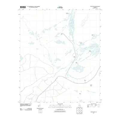
2011 Map of The Pocket
USGS Topo · Published 2011About this map
The Suwannee River and its intricate tributaries dominate this landscape within the Okefenokee Swamp region, where the North Fork Suwannee River and Bay Creek converge. A defining engineered feature of the area is the Suwannee River Sill, which stretches through the wetlands toward Pine Island. This 2011 survey documents a terrain defined by hammocks and islands—slight elevations in the swamp that have historically served as landmarks and localized dry ground. Names like Mixons Hammock, Cravens Hammock, and Macks Island reflect the long-standing human presence and family ties to these specific landforms. Further south, the map details the area known as The Pocket, situated near Honey Scrub Island and Jack Island. The absence of dense road networks highlights the preserved nature of these wetlands at the start of the 21st century.
Find a feature on this map
14 named features on this map. Tap any name to fly to it.
Don’t see what you’re looking for? This feature index may not catch every label — zoom into the map to look around manually.
Map Details
Editions of this 2011 The Pocket Map
This is the sole edition of this map. No revisions or reprints were ever made.
Other maps of this area

1954 · Valdosta
USGS Topo · 1:250,000

1958 · Valdosta
USGS Topo · 1:250,000

1959 · Valdosta
USGS Topo · 1:250,000

1965 · Blackjack Island
USGS Topo · 1:24,000

1965 · Dinner Pond
USGS Topo · 1:24,000
1966 · Billys Island
USGS Topo · 1:24,000

1966 · The Pocket
USGS Topo · 1:24,000

1966 · Cravens Island
USGS Topo · 1:24,000

1967 · Strange Island
USGS Topo · 1:24,000

1967 · Spooner
USGS Topo · 1:24,000