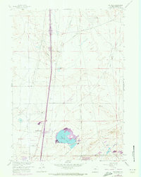
1961 Map of The Reefs
USGS Topo · Published 1973About this map
The geological ridge known as The Reefs dominates the northern terrain of this Natrona County landscape, surveyed initially in 1947 and updated via aerial photography in the early 1970s. The region is characterized by an extensive network of pipelines and energy infrastructure, including an Abandoned Oil Tank Farm and scattered Oil Wells. The small settlement at Richardson Acres sits near the intersection of these industrial corridors and the primary highway, providing a rare residential footprint in an otherwise industrial and topographic expanse. To the east, Harford Field serves the local aviation needs, while prominent water features like Soda Lake and Ninemile Lake break the arid basin. This map documents a period of significant industrial transition as the energy infrastructure of Wyoming expanded around established natural landmarks.
Find a feature on this map
16 named features on this map. Tap any name to fly to it.
Don’t see what you’re looking for? This feature index may not catch every label — zoom into the map to look around manually.
Map Details
Editions of this 1961 The Reefs Map
4 editions found
Other maps of this area

1949 · Brookhurst
USGS Topo · 1:24,000

1949 · Pratts Soda Lakes
USGS Topo · 1:24,000

1950 · Brookhurst
USGS Topo · 1:24,000

1950 · Pratts Soda Lakes
USGS Topo · 1:24,000

1950 · Goose Egg
USGS Topo · 1:24,000

1951 · The Reefs
USGS Topo · 1:24,000

1951 · Casper
USGS Topo · 1:24,000

1952 · Bishop
USGS Topo · 1:24,000

1955 · Arminto
USGS Topo · 1:250,000

1955 · Casper
USGS Topo · 1:250,000