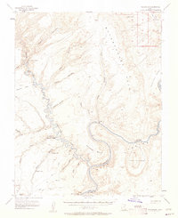
1953 Map of The Rincon
USGS Topo · Published 1961About this map
The Colorado River and Escalante River converge in this high-desert canyon system, showing the landscape as it appeared in the early 1950s before significant changes to the river flow. The map documents the intricate drainage patterns of Stevens Canyon, Cow Canyon, and Explorer Canyon as they cut through the massive sandstone formations. A primary geographic focal point is The Rincon, an abandoned meander of the Colorado River that stands as a distinctive landmark within Glen Canyon.
Find a feature on this map
41 named features on this map. Tap any name to fly to it.
Don’t see what you’re looking for? This feature index may not catch every label — zoom into the map to look around manually.
Map Details
Editions of this 1953 The Rincon Map
3 editions found
Other maps of this area

1886 · Escalante
USGS Topo · 1:250,000

1886 · Henry Mountains
USGS Topo · 1:250,000

1892 · Henry Mountains
USGS Topo · 1:250,000

1953 · Mt Pennell 3 SW
USGS Topo · 1:24,000

1953 · Navajo Mountain 4 NW
USGS Topo · 1:24,000

1953 · Cummings Mesa
USGS Topo · 1:62,500

1953 · The Rincon
USGS Topo · 1:62,500

1953 · Lake Canyon
USGS Topo · 1:62,500

1953 · Mt. Ellsworth
USGS Topo · 1:62,500

1953 · Hall Mesa
USGS Topo · 1:62,500