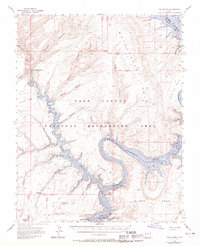
1953 Map of The Rincon
USGS Topo · Published 1970About this map
The Rincon stands as the central landmark of this canyon country, where the winding course of the Colorado River meets the expansive waters of Lake Powell. This 1950s survey, updated with 1960s corrections, documents the transition of the landscape into the Glen Canyon National Recreation Area. Significant historical sites like the Hole-in-the-Rock and the Hole-in-the-Rock Historical Marker denote the path of early pioneers through the sandstone corridors of Kane and San Juan counties. The map illustrates a labyrinth of drainage systems including Stevens Canyon, Bowns Canyon, and Coyote Creek, which feed into the river system. Geologic features such as the Water Pocket Fold and Iron Top Mesa dominate the eastern portion of the sheet, while specific points of interest like the Cathedral in the Desert and Stevens Natural Arch are noted within the deep canyon walls.
Find a feature on this map
28 named features on this map. Tap any name to fly to it.
Don’t see what you’re looking for? This feature index may not catch every label — zoom into the map to look around manually.
Map Details
Editions of this 1953 The Rincon Map
3 editions found
Other maps of this area

1886 · Escalante
USGS Topo · 1:250,000

1886 · Henry Mountains
USGS Topo · 1:250,000

1892 · Henry Mountains
USGS Topo · 1:250,000

1953 · Mt Pennell 3 SW
USGS Topo · 1:24,000

1953 · Navajo Mountain 4 NW
USGS Topo · 1:24,000

1953 · Cummings Mesa
USGS Topo · 1:62,500

1953 · The Rincon
USGS Topo · 1:62,500

1953 · Lake Canyon
USGS Topo · 1:62,500

1953 · Mt. Ellsworth
USGS Topo · 1:62,500

1953 · Hall Mesa
USGS Topo · 1:62,500