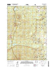
2014 Map of The Twins
USGS Topo · Published 2014About this map
The Twins and Maiden Peak dominate this section of the high Cascade Range, where the boundary between Lane Co and Deschutes Co follows the crest of the mountains. This landscape is defined by its volcanic peaks and high-elevation basins, primarily protected within the Willamette National Forest and Deschutes National Forest. The Pacific Crest National Scenic Trail winds through the western portion of the quadrangle, passing just below the summit of The Twins and providing access to remote water bodies like Charlton Lake and Bobby Lake. A network of Forest Service roads, including Nat For Dev Rd 5897 and Nat For Dev Rd 4296, provides the only vehicular access to this wilderness. Small alpine lakes such as Found Lake, Hidden Lake, and Johnny Lake are scattered across the uneven plateau, fed by seasonal drainages like Charlton Cr and Moore Cr.
Find a feature on this map
33 named features on this map. Tap any name to fly to it.
Don’t see what you’re looking for? This feature index may not catch every label — zoom into the map to look around manually.
Map Details
Editions of this 2014 The Twins Map
This is the sole edition of this map. No revisions or reprints were ever made.
Other maps of this area
1925 · Waldo Lake
USGS Topo · 1:125,000
1930 · Maiden Peak
USGS Topo · 1:125,000
1934 · Maiden Peak
USGS Topo · 1:125,000
1955 · Chucksney Mtn
USGS Topo · 1:62,500

1955 · Crescent
USGS Topo · 1:250,000
1956 · Waldo Lake
USGS Topo · 1:62,500

1957 · Crescent
USGS Topo · 1:250,000

1958 · Crescent
USGS Topo · 1:250,000

1958 · Roseburg
USGS Topo · 1:250,000

1959 · Roseburg
USGS Topo · 1:250,000