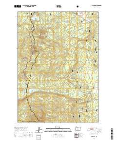
2020 Map of The Twins
USGS Topo · Published 2020About this map
The high volcanic peaks of the Cascade Range define this high-altitude landscape along the border of Lane and Deschutes Counties. Centered on the prominent summits of The Twins and Maiden Peak, the terrain is marked by a complex network of recreational corridors that follow ancient geographic pathways. The Pacific Crest National Scenic Trail winds north-to-south through the western portion of the map, passing near Bobby Lake and Twins Peak, while the Metolius-Windigo trail traverses the eastern slopes. The seasonal nature of access in the Willamette and Deschutes National Forests is evident through the inclusion of winter-specific routes such as the Waldo Snowmobile path and Upper Moore Creek (Snow). Small mountain lakes like Charlton Lake and Found Lake are scattered across the timbered basins between cinder cones like Gerdine Butte, illustrating a wilderness shaped by both glacial activity and relatively recent volcanic history.
Find a feature on this map
33 named features on this map. Tap any name to fly to it.
Don’t see what you’re looking for? This feature index may not catch every label — zoom into the map to look around manually.
Map Details
Editions of this 2020 The Twins Map
This is the sole edition of this map. No revisions or reprints were ever made.
Other maps of this area

1925 · Waldo Lake
USGS Topo · 1:125,000

1930 · Maiden Peak
USGS Topo · 1:125,000

1934 · Maiden Peak
USGS Topo · 1:125,000

1955 · Chucksney Mtn
USGS Topo · 1:62,500

1955 · Crescent
USGS Topo · 1:250,000

1956 · Waldo Lake
USGS Topo · 1:62,500

1957 · Crescent
USGS Topo · 1:250,000

1958 · Crescent
USGS Topo · 1:250,000

1958 · Roseburg
USGS Topo · 1:250,000

1959 · Roseburg
USGS Topo · 1:250,000