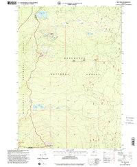
1997 Map of The Twins
USGS Topo · Published 2001About this map
Pacific Crest National Scenic Trail traverses the high country of the central Cascades, winding past prominent volcanic landmarks and a network of high-elevation basins. The terrain is defined by the sharp rise of The Twins and Maiden Peak, which dominate the central and southern portions of the sheet. Between these summits, a complex system of alpine hydrology is visible, featuring Charlton Lake, Bobby Lake, and smaller water bodies like Hidden Lake and Found Lake.
Find a feature on this map
22 named features on this map. Tap any name to fly to it.
Don’t see what you’re looking for? This feature index may not catch every label — zoom into the map to look around manually.
Map Details
Editions of this 1997 The Twins Map
This is the sole edition of this map. No revisions or reprints were ever made.
Other maps of this area

1925 · Waldo Lake
USGS Topo · 1:125,000

1930 · Maiden Peak
USGS Topo · 1:125,000

1934 · Maiden Peak
USGS Topo · 1:125,000

1955 · Chucksney Mtn
USGS Topo · 1:62,500

1955 · Crescent
USGS Topo · 1:250,000

1956 · Waldo Lake
USGS Topo · 1:62,500

1957 · Crescent
USGS Topo · 1:250,000

1958 · Crescent
USGS Topo · 1:250,000

1958 · Roseburg
USGS Topo · 1:250,000

1959 · Roseburg
USGS Topo · 1:250,000