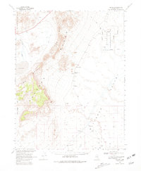
1968 Map of The Wall
USGS Topo · Published 1981About this map
The high desert terrain of central Nevada is defined here by the meeting of the The Wall Range and the Pancake Range, framing a landscape of isolated water sources and industrial exploration. Mapped in the late 1960s, the area shows a distinct pattern of reliance on sparse springs and wells, such as Coyote Hole Spring, Abel Spring, and Pigeon Well. These features served as critical nodes for livestock and travelers moving through the Big Sand Springs Valley and across Chuck Wagon Flat. Evidence of geological interest is found in the Cinder Pits and various Prospects scattered near the mountains. To the east, the Railroad Valley Wildlife Management Area encompasses the lowlands near Warm Spring, where an indefinite boundary marks the transition into the vast Railroad Valley.
Find a feature on this map
19 named features on this map. Tap any name to fly to it.
Don’t see what you’re looking for? This feature index may not catch every label — zoom into the map to look around manually.
Map Details
Editions of this 1968 The Wall Map
2 editions found

Other maps of this area

1956 · Lund
USGS Topo · 1:250,000

1956 · Tonopah
USGS Topo · 1:250,000

1959 · Tonopah
USGS Topo · 1:250,000

1960 · Lund
USGS Topo · 1:250,000

1962 · Tonopah
USGS Topo · 1:250,000

1964 · Blue Eagle Springs
USGS Topo · 1:62,500

1964 · Troy Canyon
USGS Topo · 1:62,500

1967 · Lunar Crater
USGS Topo · 1:62,500

1967 · Moores Station
USGS Topo · 1:62,500

1967 · Moores Station SE
USGS Topo · 1:24,000