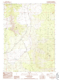
1986 Map of The Whaleback
USGS Topo · Published 1986About this map
Klamath National Forest and Shasta National Forest meet in this mid-1980s topographic survey of Northern California. The terrain is dominated by prominent volcanic and geological landmarks, including the namesake shield volcano The Whaleback in the southeast and the distinctive Sheep Rock to the west. The presence of several industrial extractions, such as a Cinder Pit, Gravel Pit, and Sand Pit, indicates the area's utility for road-building materials and geological resources during this era.
Find a feature on this map
15 named features on this map. Tap any name to fly to it.
Don’t see what you’re looking for? This feature index may not catch every label — zoom into the map to look around manually.
Map Details
Editions of this 1986 The Whaleback Map
This is the sole edition of this map. No revisions or reprints were ever made.
Other maps of this area

1886 · Shasta
USGS Topo · 1:250,000

1894 · Shasta
USGS Topo · 1:250,000

1922 · Shasta Valley Sheet No 10 E
USGS Topo · 1:24,000

1934 · Macdoel
USGS Topo · 1:96,000

1935 · Dunsmuir
USGS Topo · 1:125,000

1941 · Macdoel
USGS Topo · 1:125,000

1948 · Weed
USGS Topo · 1:250,000

1950 · Weed
USGS Topo · 1:250,000

1954 · The Whaleback
USGS Topo · 1:62,500

1954 · Shasta
USGS Topo · 1:62,500