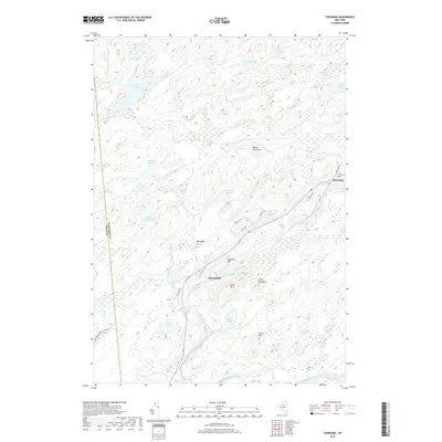
2019 Map of Thendara
USGS Topo · Published 2019About this map
The settlement of Thendara serves as a northern gateway within the Adirondack Park Preserve along the Middle Branch Moose River. This region is defined by a dense network of water bodies and prominent peaks, including Moose River Mtn and Flatrock Mtn. The landscape shows a distinct pattern of accessibility, with concentrated development near the river corridors and along Old Rte 28, while the interior remains a complex of wetlands and smaller ponds like Cedar Pond and Gull Lake. To the west, the expansive Big Otter Lake dominates the drainage system, fed by tributaries such as Tommy Roaring Cr and N Inlet. Near the small settlement of Minnehaha, the terrain is marked by family-named landmarks like Jones Mtn and Tooker Mtn, reflecting the area's history as a destination for seasonal residence and wilderness recreation.
Find a feature on this map
52 named features on this map. Tap any name to fly to it.
Don’t see what you’re looking for? This feature index may not catch every label — zoom into the map to look around manually.
Map Details
Editions of this 2019 Thendara Map
This is the sole edition of this map. No revisions or reprints were ever made.
Other maps of this area

1901 · Old Forge
USGS Topo · 1:62,500

1903 · Big Moose
USGS Topo · 1:62,500

1912 · Number Four
USGS Topo · 1:62,500

1912 · Mc Keever
USGS Topo · 1:62,500

1915 · Number Four
USGS Topo · 1:62,500

1950 · Utica
USGS Topo · 1:250,000

1954 · Old Forge
USGS Topo · 1:62,500

1954 · Big Moose
USGS Topo · 1:62,500

1957 · Utica
USGS Topo · 1:250,000
1957 · Number Four
USGS Topo · 1:62,500