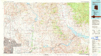
1994 Map of Theodore Roosevelt Lake
USGS Topo · Published 1995About this map
Theodore Roosevelt Lake anchors this 1994 record of the Salt River system, showcasing a massive chain of reservoirs and hydroelectric infrastructure including the Theodore Roosevelt Dam, Horse Mesa Dam, and Mormon Flat Dam. To the west, the urban expansion of Phoenix and Scottsdale meets the managed wilderness of the McDowell County Regional Park. The map documents the vital water management network of the Arizona Canal and Granite Reef Aqueduct, which transformed this desert environment. Between the peaks of the Mazatzal Mountains and the Superstition Mountains, the Verde River and Salt River converge near Fort McDowell, illustrating the intersection of Indigenous lands at the Salt River Indian Reservation and early settlement outposts like Sunflower and Carefree.
Find a feature on this map
89 named features on this map. Tap any name to fly to it.
Don’t see what you’re looking for? This feature index may not catch every label — zoom into the map to look around manually.
Map Details
Editions of this 1994 Theodore Roosevelt Lake Map
3 editions found
Other maps of this area

1886 · Holbrook
USGS Topo · 1:250,000

1887 · Verde
USGS Topo · 1:250,000

1887 · Prescott
USGS Topo · 1:250,000

1892 · Verde
USGS Topo · 1:250,000

1892 · Prescott
USGS Topo · 1:250,000

1893 · Holbrook
USGS Topo · 1:250,000

1900 · Florence
USGS Topo · 1:125,000

1901 · Globe
USGS Topo · 1:62,500

1902 · Globe
USGS Topo · 1:62,500

1902 · Florence
USGS Topo · 1:125,000