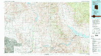
1994 Map of Theodore Roosevelt Lake
USGS Topo · Published 1995About this map
The Salt River Indian Reservation and the rising development of Scottsdale and Phoenix anchor the southwestern corner of this study, marking the edge of the urban corridor against the preserved wildlands of the Tonto National Forest. To the northeast, the landscape is defined by the massive reservoirs of the Salt River system, including Theodore Roosevelt Lake, Apache Lake, Canyon Lake, and Saguaro Lake. These water bodies, along with Bartlett Reservoir on the Verde River, show the critical infrastructure managing water across the Mazatzal Mountains and Superstition Wilderness. Small outposts like Sunflower and Punkin Center punctuate the vast mountain terrain. Cultural sites such as the Tonto National Monument near the shores of Roosevelt Lake contrast with the modern growth of Paradise Valley and Carefree, illustrating the juxtaposition of ancient habitation and late 20th-century suburban expansion in the valley.
Find a feature on this map
34 named features on this map. Tap any name to fly to it.
Don’t see what you’re looking for? This feature index may not catch every label — zoom into the map to look around manually.
Map Details
Editions of this 1994 Theodore Roosevelt Lake Map
3 editions found
Other maps of this area

1886 · Holbrook
USGS Topo · 1:250,000

1887 · Verde
USGS Topo · 1:250,000

1887 · Prescott
USGS Topo · 1:250,000

1892 · Verde
USGS Topo · 1:250,000

1892 · Prescott
USGS Topo · 1:250,000

1893 · Holbrook
USGS Topo · 1:250,000

1900 · Florence
USGS Topo · 1:125,000

1901 · Globe
USGS Topo · 1:62,500

1902 · Globe
USGS Topo · 1:62,500

1902 · Florence
USGS Topo · 1:125,000