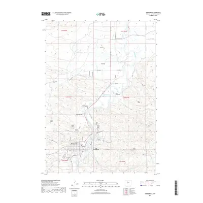
2017 Map of Thermopolis
USGS Topo · Published 2017About this map
Thermopolis and East Thermopolis anchor the southern reach of this survey, where the Bighorn River cuts through a landscape defined by geothermal activity and early irrigation. The presence of the Thermopolis Hot Spring and Black Sulphur Spring near the river bank highlights the area's geological character, while man-made water systems like Dempsey Canal, S Side Ditch, and Kirby Ditch trace the efforts to green the valley for agriculture. Genealogists will find a cluster of burial grounds including Riverside Cem, Smoky Row Cem, and the Milek Family Cem situated near the river's bend. Northward, the small settlements of Red Lane and Lucerne represent the rural development of Hot Springs County. High points such as Round Top, T Hill, and Monument Hill overlook the river valley, providing natural landmarks between the irrigated flats and the rising terrain of Cedar Ridge and Blue Ridge.
Find a feature on this map
59 named features on this map. Tap any name to fly to it.
Don’t see what you’re looking for? This feature index may not catch every label — zoom into the map to look around manually.
Map Details
Editions of this 2017 Thermopolis Map
This is the sole edition of this map. No revisions or reprints were ever made.
Other maps of this area

1914 · Blue Mesa
USGS Topo · 1:62,500

1916 · Blue Mesa
USGS Topo · 1:62,500

1945 · Kirby
USGS Topo · 1:62,500

1946 · Kirby
USGS Topo · 1:62,500

1955 · Thermopolis
USGS Topo · 1:250,000

1958 · Thermopolis
USGS Topo · 1:250,000

1960 · Devil Slide
USGS Topo · 1:24,000

1960 · Red Hole
USGS Topo · 1:24,000
1960 · Wedding Of The Waters
USGS Topo · 1:24,000

1960 · Thermopolis
USGS Topo · 1:24,000