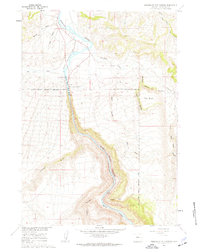
1960 Map of Wedding Of The Waters
USGS Topo · Published 1962About this map
The Wedding of the Waters (Historical Marker) marks a rare geographic transition where the Wind River officially becomes the Bighorn River as it flows north through a dramatic canyon gap. This 1960 survey illustrates the rugged corridor of the Chicago Burlington and Quincy railroad as it follows the river's path, cutting through deep terrain features like Windy Point and Buffalo Canyon.
Find a feature on this map
29 named features on this map. Tap any name to fly to it.
Don’t see what you’re looking for? This feature index may not catch every label — zoom into the map to look around manually.
Map Details
Editions of this 1960 Wedding Of The Waters Map
2 editions found
Other maps of this area

1951 · Boysen
USGS Topo · 1:24,000

1951 · Birdseye Pass
USGS Topo · 1:24,000

1951 · Morrison Canyon
USGS Topo · 1:24,000

1955 · Thermopolis
USGS Topo · 1:250,000

1958 · Thermopolis
USGS Topo · 1:250,000

1960 · Devil Slide
USGS Topo · 1:24,000

1960 · Red Hole
USGS Topo · 1:24,000

1960 · Thermopolis
USGS Topo · 1:24,000

1962 · Thermopolis
USGS Topo · 1:250,000
1965 · Nostrum Mountain
USGS Topo · 1:24,000