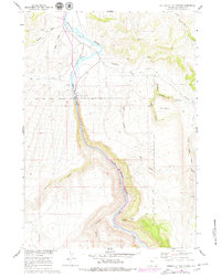
1960 Map of Wedding Of The Waters
USGS Topo · Published 1980About this map
The Wedding of the Waters marks a significant hydrologic transition point in this landscape where the northward-flowing river changes names from the Wind River to the Bighorn River. This 1960 survey, updated with 1975 photographic revisions, documents the corridor of the Chicago Burlington and Quincy railroad as it winds through the canyon alongside the water. The boundary of the Wind River Indian Reservation cuts across the southern portion of the map, separating the high plateaus of The Block from the lower river valley. Evidence of local infrastructure includes the Fourmile Bridge and the small settlement of Minnesela, set against a backdrop of complex drainage systems like Buffalo Canyon and Grass Creek Canyon.
Find a feature on this map
27 named features on this map. Tap any name to fly to it.
Don’t see what you’re looking for? This feature index may not catch every label — zoom into the map to look around manually.
Map Details
Editions of this 1960 Wedding Of The Waters Map
2 editions found
Other maps of this area

1951 · Boysen
USGS Topo · 1:24,000

1951 · Birdseye Pass
USGS Topo · 1:24,000

1951 · Morrison Canyon
USGS Topo · 1:24,000

1955 · Thermopolis
USGS Topo · 1:250,000

1958 · Thermopolis
USGS Topo · 1:250,000

1960 · Devil Slide
USGS Topo · 1:24,000

1960 · Red Hole
USGS Topo · 1:24,000
1960 · Wedding Of The Waters
USGS Topo · 1:24,000

1960 · Thermopolis
USGS Topo · 1:24,000

1962 · Thermopolis
USGS Topo · 1:250,000