
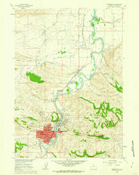
1960 Map of Thermopolis
USGS Topo · Published 1962About this map
Hot Springs State Park serves as the focal point for this Wyoming landscape, where the Bighorn River carves a deep path through the terrain. The geothermal activity of the area is mapped in significant detail, featuring landmarks like Big Spring, the Rainbow Tepee Fountain, Black Sulphur Spring, and the curiously named Devils Punch Bowl. This 1960 survey illustrates the town of Thermopolis and East Thermopolis during a period of established local industry, evidenced by a Refinery near the riverbanks and the presence of the Chicago Burlington and Quincy railroad line. Transportation and water management define the surrounding countryside, with the Dempsey Canal and South Side Ditch branching out to support the high desert valley. From the Monument Hill Cem to the north and Riverside Cem to the south, the map preserves the civic layout of the county seat and the outlying settlement of Lucerne.
Find a feature on this map
53 named features on this map. Tap any name to fly to it.
Don’t see what you’re looking for? This feature index may not catch every label — zoom into the map to look around manually.
Map Details
Editions of this 1960 Thermopolis Map
2 editions found
Other maps of this area

1914 · Blue Mesa
USGS Topo · 1:62,500

1916 · Blue Mesa
USGS Topo · 1:62,500

1945 · Kirby
USGS Topo · 1:62,500

1946 · Kirby
USGS Topo · 1:62,500

1955 · Thermopolis
USGS Topo · 1:250,000

1958 · Thermopolis
USGS Topo · 1:250,000

1960 · Devil Slide
USGS Topo · 1:24,000

1960 · Red Hole
USGS Topo · 1:24,000
1960 · Wedding Of The Waters
USGS Topo · 1:24,000

1962 · Thermopolis
USGS Topo · 1:250,000